أداة تحويل الصور المنحية في الدرونDroneception Mission Maker for Litchi


Droneception Mission Maker for Litchi
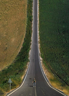
A "droneception" image is a "mind-bending" photo montage where it looks like the ground is bending upward as you look into the distance. The inspiration of this type of image is from the movie Inception (see photo). Creating a "droneception" image requires three primary steps, each presenting a different type of challenge:
Identify a subject that will look good.
Take a series of photos with a drone at various heights and distances.
Use photo editing software to blend the individual photographs into a single, warped photo montage.
Identify a subject that will look good
From examples I have seen on the web (there are many), a good subject for a "droneception" photo montage includes:
Here is a little tool to help you made such photos with your drone. https://www.wesbarris.com/drone/droneception.php
A rarely-travelled road going off into the distance
A point of interest located on or around the road in the distance
Not too many objects on either side of the road (which will make the final blending process more difficult)
Take a series of photos with a drone
This web application provides an easy, repeatable method for generating a series of photos. The application not only determines the height and position for each image but will also define camera actions in the file that will be imported into Litchi. The result is a Litchi mission that automatically captures all photos as the mission is flown. Be sure to set your camera to manual mode. Auto mode will most likely cause the photos to be taken with different exposures.
Blend the series of photos into one
This step is done using photo editing software such as Photoshop. The general idea is to import each image into a different layer and then use warping functions and masks to overlay and blend the layers into a seamless montage. People with some Photoshop (or equivalent) experience shouldn't find this too difficult. There are tutorials and instruction videos describing this process on the web. It is easy to find them by searching.
Recent Enhancements
New Path Computation Option: There is now a choice of two different methods for computing the waypoint heights and gimbal pitch angles.
Empirical: The waypoint distances from the POI are evenly spaced. The height of each waypoint is computed based on a fraction of the remaining height. The fraction is empirically calculated based on the number of waypoints. The gimbal pitch angles are then computed at each waypoint. This is the original algorithm.
Logarithmic: The waypoint distances from the POI are evenly spaced. The change in gimbal pitch angles between waypoints is constant and computed based on the number of waypoints. The height of each waypoint is computing using log(n) base(m) where n is the waypoint number and m is the number of waypoints. This is a new algorithm.
Improved Waypoint/Camera Actions: Despite having a heading and gimbal pitch angle defined for each waypoint, the drone does not strictly adhere to them at the first and last waypoints of a mission. To remedy this, additional waypoint/camera actions were added to each waypoint. The following actions are now performed at each waypoint:
Rotate aircraft to the correct heading
Tilt camera to the correct gimbal pitch angle
Stay for one second
Take photo
Stay for one second
This results in more accurate camera positioning at each waypoint, especially the first and last waypoints of the mission.
Cosmetic User Interface ImprovementsRecent Enhancements
New Path Computation Option: There is now a choice of two different methods for computing the waypoint heights and gimbal pitch angles.
Empirical: The waypoint distances from the POI are evenly spaced. The height of each waypoint is computed based on a fraction of the remaining height. The fraction is empirically calculated based on the number of waypoints. The gimbal pitch angles are then computed at each waypoint. This is the original algorithm.
Logarithmic: The waypoint distances from the POI are evenly spaced. The change in gimbal pitch angles between waypoints is constant and computed based on the number of waypoints. The height of each waypoint is computing using log(n) base(m) where n is the waypoint number and m is the number of waypoints. This is a new algorithm.
Improved Waypoint/Camera Actions: Despite having a heading and gimbal pitch angle defined for each waypoint, the drone does not strictly adhere to them at the first and last waypoints of a mission. To remedy this, additional waypoint/camera actions were added to each waypoint. The following actions are now performed at each waypoint:
Rotate aircraft to the correct heading
Tilt camera to the correct gimbal pitch angle
Stay for one second
Take photo
Stay for one second
This results in more accurate camera positioning at each waypoint, especially the first and last waypoints of the mission.
Cosmetic User Interface Improvements
Here is a little tool to help you made such photos with your droneالصور الجميلة لا يراها إلا المميزون أنت الأفضل..🌹
🌷وصول الأفضل اليك يعني انك من المميزين♥
🌹كل يوم صورة وفيديو ومعلومة جديدة عن #الدرونز 🌹
#تابعونا_على_قروب
#تجمع_هواة_الدرونز_dji_الاردن🇯🇴🇯🇴🇯🇴
#وبيج
#نادي_الدرون_الاردني
#Jordan_Drone_Club 🇯🇴🇯🇴🇯🇴
✅ #نرحب_بكل_هواة_الدرونز🌹🌹🌹
#تابعونا_ليصلكم_كل_جديد. https://www.wesbarris.com/drone/droneception.php


تعليقات
إرسال تعليق